

Products and services

In 1785, King Louis XVI of France commissioned Jean François de Galoup, comte de Lapérouse, to explore the Pacific Ocean, seeking to bolster French scientific prestige and imperial ambitions. The Académie des Sciences prepared a list of questions for the expedition, to settle various geographical ambiguities. One question was whether the land known as “Ségalien,” now known as Sakhalin, was an island or a peninsula.
Two years later, on a foggy July day, Lapérouse reached the shores of Sakhalin, expecting to fulfil his mission of discovery. After spending only one day onshore, he concluded that Sakhalin was an island. This finding, together with many other materials collected during the expedition, was later passed on to his crew member Jean Barthélemy de Lesseps, who embarked on an arduous overland journey across Eurasia, from Kamchatka to Paris to deliver the results of the expedition.
Philosopher Bruno Latour famously interpreted Lapérouse’s voyage as a paradigmatic example of how empirical knowledge was produced by “centers of calculation.” In Latour’s model, explorers such as Lapérouse gathered raw data through observation in distant lands, transmitting this information back to Europe, where it was processed into coherent maps and scientific understanding. The model of discovery focused on the center of calculation is symbolic of how the entire global scientific enterprise worked. According to Latour, such voyages resulted in powerful asymmetries between mobile European geographers and static local populations, rendering distant lands predictable and tamable.
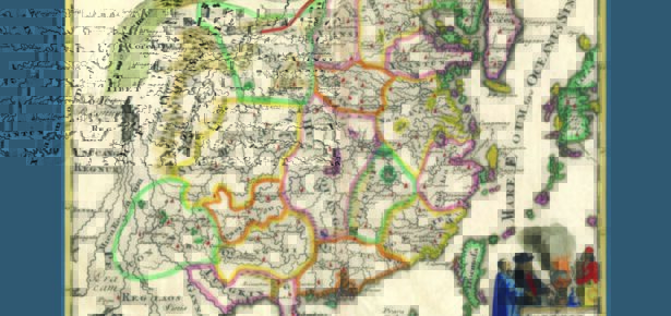
Yet, upon closer scrutiny Lapérouse’s brief stop in Sakhalin appears more complex and nuanced than Latour’s idealized model suggests. Crucially, Lapérouse’s conclusion that Sakhalin was indeed an island was not based on exploration due to the to the constraints imposed by the weather and the tight schedule of the expedition. It was based instead on information provided by the locals, who were not “natives” but, likely Chinese or Jurchen communities, who had settled the island just a century prior, after displacing the indigenous Ainu population to neighboring Hokkaido. One of these inhabitants drew a map on sand indicating the separation from the mainland, which Lapérouse promptly copied in the notebook and later passed on to the daring Lesseps. This was therefore not an act of scientific observation, but one of cartographic translation, from sand to paper and from Jurchen cartographic practice to French cartographic practice. Yet, it was not even a first instance of translation, as French maps by Jean Baptiste Bourguignon D’Anville, published a few decades before the journey of Lapérouse, clearly depicted Sakhalin as an island. These maps were themselves translations of survey maps produced in China through collaboration between Chinese, Manchu, and Jesuit surveyors at the behest of the Kangxi emperor. Indeed, the name “Sakhalin” itself was derived from the Manchu “Sahaliyan ula angga hada,” meaning “craggy rock the mouth of the Black River,” referencing what was known in Russian as the Amur River, further illustrating the translational nature of this piece of geographic knowledge.
My book Connected Cartographies: World Geography and the Sino-Western Translation of Knowledge, 1580–1842, argues that, since most early modern maps were based on other maps, cartographic translation played a crucial role in the production of geographical knowledge. Lapérouse’s encounter on Sakhalin was just one episode of a longstanding cycle of knowledge exchange and cartographic translation between Europe and China. This cycle involved the acquisition of Chinese cartographic works in Europe, their translation, and their synthesis with European Ptolemaic maps, which represented China and East Asia more generally. The process also involved the translation of early modern European world maps in China and their hybridization with Chinese traditions of cartography. These two developments were not separate but were connected through some of the same actors and materials. This phenomenon of cross-cultural exchange began in the second half of the sixteenth century, when the trickle of knowledge, people, and things already moving between Eurasia’s eastern and western ends first settled into a regular flow. The exchange lasted until the first half of the nineteenth century, as European mapmakers active in China and Chinese cartographers transitioned away from hybridizing the content of Chinese and Western maps. Connected Cartographies therefore focuses on elucidating the fascinating, multidirectional phenomenon of translation and cross-cultural exchange of knowledge that was a significant component of Sino-Western relations between the sixteenth and nineteenth centuries.
European maps of China, relying on Chinese sources, were long considered distinct from world maps in Chinese based on Western sources. However, I propose that they should be examined collectively. Maps of the world in Chinese based on European sources and European (Ptolemaic style) maps of China based on Chinese sources both form a specific type of cartographic works that stands apart from others. Their shared distinguishing feature is that they were the products of cross-cultural exchange. Examples include the world map titled Kunyu wanguo quantu 坤輿萬國全圖 (Map of Myriad Countries of the Earth) made in collaboration between the Jesuit Matteo Ricci (1552–1610), known in Chinese as Li Madou 利瑪竇, and the Ming scholar Li Zhizao 李之藻 (1571–1630), and Chinae, olim Sinarum Regio nova descriptio by Abraham Ortelius (1527–1598). Such maps could not have been created without early modern trans-Eurasian contact. This genre of cartography, which the book calls “cross-cultural cartography” or “connected cartography,” relies on the phenomenon of globalization. This is distinct from the centralization of data obtained in faraway places by explorers, adventurers, and state missions, which is a feature of the maps derived from what has been called the “Age of Discovery.”
The translational perspective Connected Cartographies advocates significantly reshapes our understanding of global scientific history. Rather than a narrative dominated by heroic explorers, it reveals a far richer tapestry woven by Chinese cartographers, Jesuit intermediaries, Manchu translators, and indigenous informants. These actors collectively mediated knowledge, creating multilingual, culturally hybrid maps that continue to shape our understanding of global geography today.

Florin-Stefan Morar is Assistant Professor of the History of Science at the National University of Singapore working on the global history of science, the history of international ...
View profile >Keep up with the latest from Cambridge University Press on our social media accounts.


Latest Comments
Have your say!